Riverside Historical Walk Brochure
- $19,794

Overview
Description
We are proud to be one of the sponsors for this brochure documenting the rich history of Riverside.
For the complete version of it please click here: Riverside Historical brochure As the images aren’t included below, just the copy. We don’t have a web friendly version of this document.
Kind Regards,
Matt & Ben
A Rich Heritage to Explore A Rich Heritage to Explore
A publication of the Riverside Business Improvement Area (BIA) www.Riverside-TO.com
The Don River The east bank of the Don river was the site of Toronto’s oldest house built for John Scadding, a clerk to Upper Canada’s first lieutenant governor John Graves in 1794. The cabin was moved to the Canadian National Exhibi- tion grounds in 1879, where it can still be visited. It is considered to be Toronto’s oldest surviving structure. In the 19th century, and into the beginning of the 20th century, the Don River Valley was an important recre- ation area for Riverside residents. On the city side of the river, swimmers had to be covered from neck to ankle; on the east-side nude swimming flourished. The Don River was straightened in the 1890’s. This is the view from the Dundas Street bridge.
Just a few blocks from downtown Toronto is Riverside, a vibrant neighbourhood with a unique small town feel that makes it a draw for residents and visitors alike. Best known for its heritage buildings, boutique shops, award-winning restaurants, and the street that inspired the internationally renowned Degrassi TV series, Riverside’s attraction also lies in its artisans and commu- nity builders of many sorts. Riverside is a great example of a neighbourhood that is drawing on its history as impetus and inspiration for its new development. The rejuvenated buildings provide the perfect settings for the many shops, restaurants and pubs that have sprung up. This urban renewal has not distracted the Riverside community from maintaining its original friendly charm.
Hamilton Tire and Rubber Company
The original site of the family business that became Canadian Tire is found on Hamilton Avenue, though the exact address is unknown. Hamilton Tire and Rubber closed in 1923 when the Billes brothers moved their operation downtown. They incorporated as the Canadian Tire Store two years later. Directions: Continue west along Queen.
(CANADIAN TIRE)
Circa 1972
Note the plaque. For many years the little lane on the west side of the Downtown Toyota building sported a “Baseball Place” street sign. This was the entrance to Toronto’s first professional ballpark, the Toronto Baseball Grounds (built in 1886), and home to Toronto’s first professional baseball championship (1887). It later became known as Sunlight Park, because of its closeness to the Lever Brothers Sunlight Soap Works. Seating capacity in the stadium was 2,200 people, and admission was 25 cents. The site was abandoned in 1896, when its home team, the Torontos, moved to Lamport Stadium in west Toronto. Directions: Walk west on Queen Street to the west side of the Riverside Bridge. Sunlight Park (665
Courtesy National Baseball Hall of Fame Cooperstown, New York
An entrance marker to Riverside created by world renowned artist Eldon Garnet in 1996, Time and a Clock is a three-part art installation. The clock and the accompanying text on the bridge refer to the Greek philosopher Heracli- tus’ notion that you cannot step into the same river twice. The text inlays at the corners of Broadview and Queen are ways of thinking about time. The four poles on the north side of Queen Street at Empire Avenue form a poem about time, while the letter at the top of each pole spell out the word TIME. Note the stairs that connect Riverside to the Pan Am trail (formerly Don Valley trail). Directions: Walk back to the east side of the Bridge.
The Canadian Bank of Commerce was designed by the noted Toronto firm of Darling and Pearson. Built in 1905, it was constructed in the classical decorative style practised in the 19th century by the Ecole des Beaux-Arts in Paris. The grand design shows the confidence in the area at that time. Directions: Walk west along the north side of Queen Street and look across to the Opera House
The Canadian Bank of Commerce (744 QUEEN STREET EAST)
Come and discover this historic neighbourhood with its distinctive architecture and heritage buildings, 4 acres of parks … and the world famous DeGrassi Street. Come and discover this historic neighbourhood with its distinctive architecture and heritage buildings, 4 acres of parks … and the world famous DeGrassi Street.
The Opera House may be one of the Toronto’s longest operating live music theatres. It was built around 1905 as a vaudeville and opera house and converted to a movie theatre in the 1920s. Today it is largely considered one of the best concert venues in Toronto. Directions: Walk west on Queen Street to Broadview Avenue. The Opera House (737 QUEEN STREET EAST)
The Broadview Hotel was built in 1891. At the time it had a large fourth-floor meeting room that sported a square grand piano. Until the 1890’s, the intersection of Queen and Broadview was the eastern entrance to Toronto. A tollgate stood in the middle of the road. Round wrought-iron water troughs for horses were at the southeast corner along with underground public washrooms. Note the sidewalk messages on each corner. Directions: Walk south to 68 Broadview Avenue.
Courtesy Metropolitan Toronto Reference Library
United Drug (68 BROADVIEW AVENUE)
This building was constructed for the United Drug Company in 1914. Founded by L.K. Liggett, it was later part of the Rexall brand where they manufactured their products and used it as a warehouse. For 20 years the main floor was a retail pharmacy and soda fountain where your grandparents may have come for a coke and some candy. Directions: Walk north to Queen and proceed west. Then look north at Hamilton.
Follow the west side of the church to a small courtyard nestled in the back of the building. The old stone cross in the courtyard garden is from the western pinnacle. Directions: Walk east to 174 First Avenue.
Rowhouses (174-188 FIRST AVENUE) These eight connected houses with mansard roofs, built in the 19th century, are becoming scarce in Toronto. Look south on West Avenue to experience the charm of another hidden pocket of Victorian Toronto. Directions: Walk west to 77 First Avenue
Toronto Chinese Alliance Church (77 FIRST AVENUE) It was built in 1885 as The First Street Baptist Church. The schoolyard across from the church (northeast corner) became a girl’s school for Domestic Arts in 1929. It is now the site of Eastdale Collegiate Institute. Directions: Walk south on Boulton Avenue to Allen Avenue.
Directions: Walk south on Boulton Avenue to Clark Street. Walk west on Clark Street to Grant Street. Walk south on Grant Street to Queen Street.
Allen Avenue was originally known as Fees Road. The Eastdale Playground at the north-west corner of the street replaces a firehall that used a tower to dry fire hoses. Just north of the park is Greig Avenue, Toronto’s shortest street. Allen Avenue
Riverside was originally a village of farmers and small merchants centered along what was to become Queen Street East. The area was annexed to the City of Toronto in 1884. This street is one of Ontario’s oldest, formerly known as Kingston Rd. and one of the primary entrances to Toronto. Along with its neighbour Leslieville, Riverside was dependent on the Don River for industry and recreation. The new association with Toronto saw the introduction of electric street lighting, new sewers, schools, cemeteries and other improvements.
In 1887, the street railway system was extended over the Don River along Queen Street East. Soon manufacturing, tanneries, clay-works and other industries began to move into the area east of the Don, clustered close to the tracks, the lake and the river. As workers moved closer to the places they worked, modest homes filled the spaces between these industries consuming the surrounding farmers fields. By the 20th century, many industries had built large factories in Riverside. These included Canada Packers, Lever Brothers, Colgate Palmolive, Dunlop Tire & Rubber and Consumers Gas.
Riverside became a solidly working class district and remained that way until the late 1950s. By the early 1960s, the largely British-Canadian composition of the neighbourhood began to change. Asians, Vietnamese, Italians, and others moved into the area and made their presence felt. By the 1970’s most of Riverside’s factories began to close. New ventures, notably television and film studios centered around Eastern Avenue, replaced those industries.
As you walk along, look up above the shops to observe the intricate brickwork and windows Directions: Walk east on Queen Street to Boulton Avenue.
The Tour The Tour This walking tour takes you through Riverside’s past and present. You will see stately commercial buildings and diminutive workers’ cottages from the 19th century. You’ll discover where people worked, played and prayed. And you’ll experience the unique flavour and character of Riverside that has made it one of Toronto’s most fascinating communities. Approximate walking time: 60-90 minutes
Courtesy of Jim Houston
Located at the corner of Boulton Avenue, this building inscribed “Poulton Block, 1885,” was originally built as “Orient Hall”, a freemasons lodge. In the 1920’s it housed the first public library east of the Don. Directions: Walk east to DeGrassi Street.
Poulton Block (792 QUEEN STREET EAST)
This small park was the site of the former Grand Trunk Railway Station (circa 1854 to 1974). The Grand Trunk Railway Station provided nation-wide train travel. Continue north on DeGrassi.
Charming cottages from the 19th century Riverside are at 52, 60, 62, and 65 DeGrassi. Note the Mansard roof and the “fish scale” tiles on numbers 67 and 69.
The small park on the northeast corner of DeGrassi and Cummings was the site of the first St Matthews church (circa 1875). After crossing Dundas Street you will see numbers 167, 169, 171 and 173 DeGrassi. James Dawson built these houses in 1888. Directions: Walk east on First Avenue.
Site of the former Grand Trunk Railway Station (TRIANGULAR PARK JUST BEFORE WARDELL ST.))
St. Matthew’s Church was built in 1890. It cost $19,794 to build, and 100,000 bricks were donated by local brickyards.
St Matthew’s and St. John’s Church (135 FIRST AVENUE)
DeGrassi Street was named for Alfro DeGrassi, a local grocer and the descendant of Philippe DeGrassi, a British Army Officer who came to Canada in 1831. During the 1837 Rebellion of Upper Canada, Philippe’s two daughters gained famed when they broke through rebel lines to warn the government about the coming invasion by William Lyon Mackenzie’s rag-tag forces. DeGrassi’s fame did not end in 1837. The television series DeGrassi Jr. High, which aired on CBC T.V. from 1987 to 1991, was based on the school at DeGrassi and Gerrard Street. At the N.E. corner of DeGrassi & Queen is a plaque marking the history of the Grand Trunk Railway Station. Directions: Walk north on DeGrassi Street. Look to the east corner of DeGrassi Street and Wardell Street DeGrassi Street4
www.Leslieville.com Matt Casselman, Ben Ferguson and Solina Bradshaw Sales Representatives
We live, love and sell the lower east side.
www.mattandben.ca 416 465-7850
Courtesy of Jim Houston
Address
Details
Updated on June 21, 2025 at 10:01 pm-
Price $19,794
-
Property Status For Sale
Mortgage Calculator
-
Down Payment
-
Loan Amount
-
Monthly Mortgage Payment
-
Property Tax
-
Home Insurance
-
PMI
-
Monthly HOA Fees
Schedule a Tour
What's Nearby?
Contact Information
View ListingsSimilar Listings
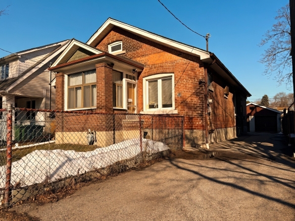
New Leslieville Listing: 51 Alton Ave
51, Alton Avenue, South Riverdale, Toronto—Danforth, Toronto, Golden Horseshoe, Ontario, M4L 1C3, Canada Details- $999,900
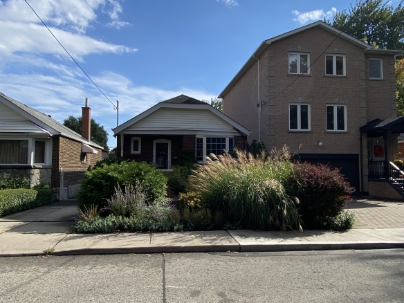
New Leslieville Listing: 41 Richard Ave
41, Richard Avenue, Greenwood-Coxwell, Toronto—Danforth, Toronto, Golden Horseshoe, Ontario, M4L 1Y9, Canada Details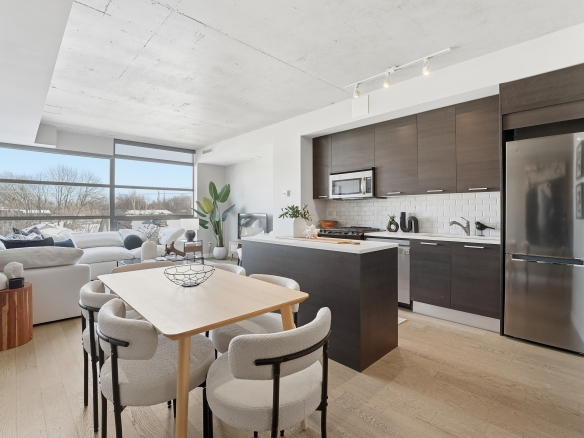
New Leslieville Listing: 90 Broadview Unit 305
The Ninety, 90, Broadview Avenue, South Riverdale, Toronto—Danforth, Toronto, Golden Horseshoe, Ontario, M4M 2H5, Canada Details- $789,000
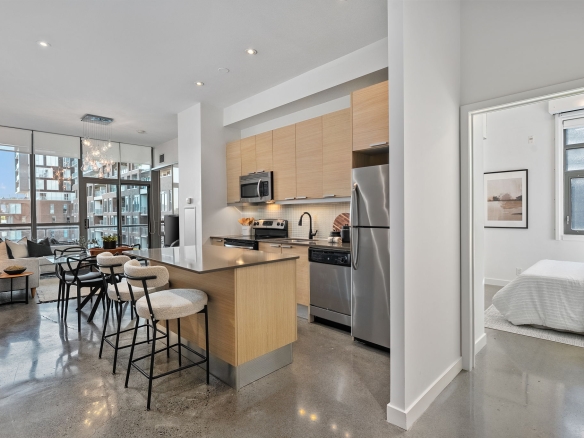
New Leslieville Listing: 625 Queen St E Unit 503
Edge Lofts, 625, Queen Street East, South Riverdale, Toronto—Danforth, Toronto, Golden Horseshoe, Ontario, M4M 1G3, Canada Details- Ben Ferguson